

Soil Sage
Soil Management Plans: Simplified
.jpg)
Looking for a Soil Management Plan Template? Look no further!
The right map layers in the right place
DEFRA requires a range of risk map layers including run-off risk, erosion risk, wind erosion risk and nitrate leaching risk. Our platform automatically provides these layers using data from the Environment Agency and British Geological Survey.

Sensitive areas identified
Our system automatically retrieves boreholes and water features within 50m of every field. It also checks whether each field overlaps with any sensitive areas (e.g. NVZs, SSSIs, Historic Battlefields and many more).

Smart proposals
Developed in close association with dozens of independent farm advisors; proposals for each field are automatically generated based on its land use, slope, soil texture and other environmental attributes.

Editable
We know you're the experts when it comes to your farms. You therefore have the power to edit proposals, risk scores, boreholes and water features to ensure your plan is accurate.

Upgrade to generate your report in minutes
All of the required information to get you through an RPA inspection is bundled into a report you can be proud of (£200 per SBI number for full reporting per year - discounted rates available for agronomists/farms looking to upgrade multiple SBIs).

.gif)
Plans with Soil Benchmark"
On 04/02 & 20/02 we will be running introductory webinars at 12:00
Sign up using the links below:
Try it for yourself!

Get started in 30 seconds
Create your account
Sign up with just an email address.
Add your farm
Use your SBI number to import field boundaries (or pick your fields in Wales or Scotland).
Fine tune your plan
Combine all of the automatically populated layers of environmental and compliance data with your own knowledge to finalise your plan.
.gif)

John Snow
Farm Hand, Winterfell


Independent
Our platform is completely independent, and is guided by data from leading environmental organisations.
Smart
Our plans use nationally trusted datasets and cutting edge analysis to do the heavy lifting for you.
Affordable
It's completely free to get started on the platform; we only charge for the full Soil Management Plan (£200 per farm per year).
Easy to use
An intuitive interface which you can get used to in no time.
Our happy customers
"Very easy piece of software to use. The team are all very helpful if you have a problem... and they are always asking us what we would like to see improved."
"Soil benchmark has been an absolute lifesaver... It really has been a huge asset to our business and the support from the team is outstanding."
"Easy to use, helps keep you compliant with industry standards and there are some brilliant features that allow you to get a more in-depth understanding of land! Highly recommend!"
Designed for Farmers & Advisors

Independent, always
We're completely independent, offering an unbiased, data-driven platform without trying to push specific products or inputs. We're not owned by or in partnership with any of the big distributors.

Adapting to meet your needs
With the agility of a start-up at our core, we rapidly adapt our platforms to suit your needs. We're proud to have developed our features in close association with farmers and advisors.

Leveraging soil science expertise
With our co-founder Ben's background as a soil scientist, our platform reflects a depth of understanding that unearths hidden value to help you manage your soils.

Your data, no ifs or buts
We share your passion for improving soil health and respect your data privacy. We're not here to 'nick' your data, but to contribute to healthier soil, just like you.

Smarter land management starts here

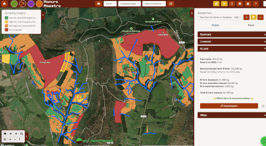
Manure Management
NVZ and Farming Rules for Water compliant Manure Management Plans.
.jpg)

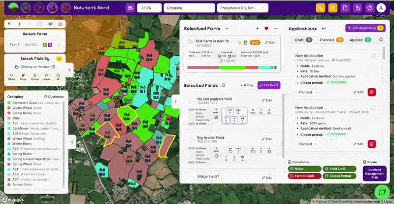
Nutrient Management
Nutrient Management plans for both SFI NUM1 and Red Tractor audits, with Farming Rules for Water and NVZ compliance checks built in.
.jpg)
%20(1).png)
Crop Rex
Quickly and easily create Spray Recommendations for pesticide applications - and check they are compliant
.jpg)
.gif)
Frequently Asked Questions
Still got questions? Email info@soilbenchmark.com or book a call with us via Calendly.
It's super quick:
- Create an account - no card details required, just add your email and accept the T&Cs.
- Add an SBI number so we can extract your field boundaries. If you’re in Scotland or Wales simply upload a shapefile or select your fields from the map – no drawing round fields!
- Sit back and relax whilst the relevant soil and environmental data for your fields is scraped from our database.
Our platform uses your field boundaries (retrieved from your SBI number) to pre-populate your farm with nearly all of the information required to complete a Soil, Manure or Nutrient Management Plan or a Spray Rec.
Yes! Please book a call to arrange a 30 minute demo.
The background data we use to drive our platform is currently restricted to England, Scotland and Wales.
If you are a farmer or agronomist outside of Great Britain and are interested in using our tools, please book a call and we can discuss expanding our coverage to your location.
Its completely free to start using Soil Benchmark.
Without paying a penny you can add as many farms as you like, and use almost all the features of the platform. That could be viewing and editing the pre-populated risk maps, soil maps, details of waterways and sensitive areas, and auto-suggested management actions in Soil Sage mode. Or getting RB209 nutrient recommendations, planning manure or fertiliser applications, and checking NVZ compliance in Nutrient Nerd mode. Or creating - and checking the legality of pesticide spray recommendations in Crop Rex mode.
We only charge to export or share this information outside the platform (either via our reports, or via our map snapshot feature). Our main two reporting modes (Soil Sage and Nutrient Nerd) each cost £200 per farm per year to upgrade:
- Soil Sage allows you to create and export fully compliant Soil Management Plans for SFI SAM1 – worth £6 / ha
- Nutrient Nerd allows you to create and export fully compliant Nutrient Management Plans, for SFI NUM1, Environment Agency inspections, or Red Tractor compliance
You only pay when you are ready, and you can choose to convert any number of the farms you have loaded onto the system, for only the plans you require.
Discounts are automatically applied on Soil Sage for very small farms, scaling down to £100 per farm per year for the smallest farms.
We also offer a discounted rates of £150/farm for agronomists, advisors and contract farmers looking to upgrade multiple farms. Please book a call or get in touch if you would think you qualify for this discount.
Crop Rex (with the ability to create and share spray recommendations) is currently free until 31st July while it's in beta-testing mode, and then will cost £500 per user per year to create Spray Recs for unlimited farms.